Riverside split by the Elysian Park landslide
1937
0 0
 アメリカ > California > Los Angeles County > Los Angeles
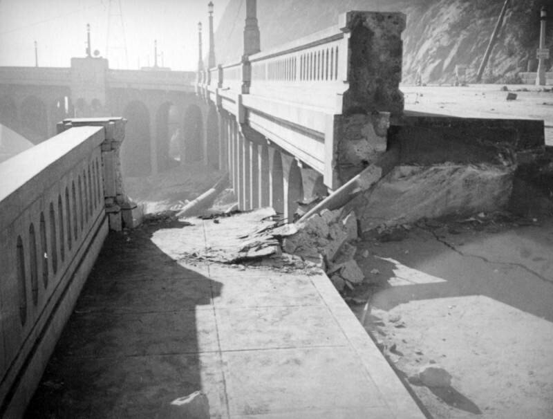
This view shows how cleanly the roadbed split and how far it was moved by the Elysian Park landslide as well as the classical construction of this version of Riverside Drive-Dayton Avenue Bridge including street lights and arched abutments.The Elysian Park landslide, which started near the top of Point Grand View (Buena Vista Peak) as a small crack in the earth and grew to 500-foot fissure over three weeks, culminated on November 26, 1937 when a million and a half tons of loose rock and dirt created a "moving mountain" destroying a 600-foot stretch of Riverside Drive. Dayton Avenue (later N. Figueroa Street) has had three different bridges. The Riverside Drive-Dayton Avenue Bridge first built in 1903 was replaced with a concrete one completed in 1928. In 1939, after the Elysian Park landslide and heavy floods in 1938, the Army Corps of Engineers built a replacement bridge with steel trussing, known as the Riverside Drive Bridge (Riverside-Figueroa Bridge) that was demolished in 2011.


daisy_dan 11/03/2020 07:12
It hasn't changed that much...