Carson Flood Area

1956

Carson Flood Area

0 0 

Uruguay Uruguay > California > Los Angeles County > Carson
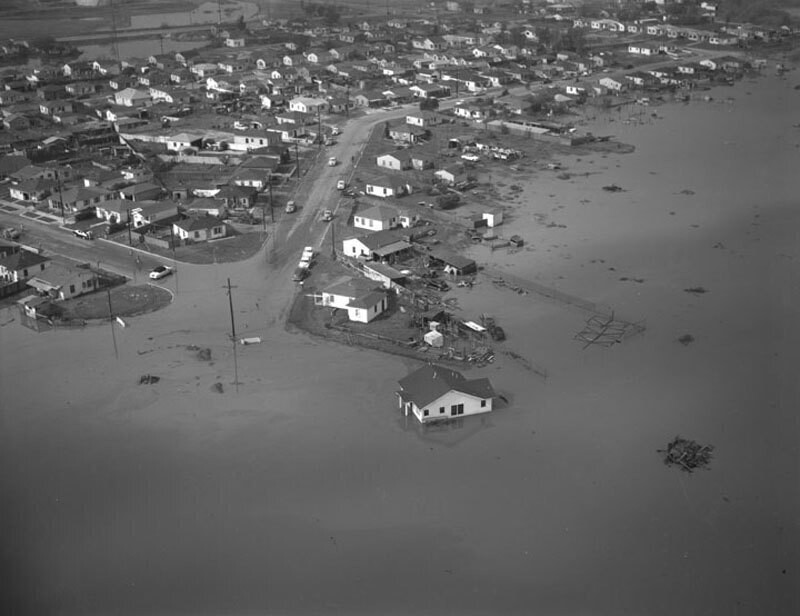
Aerial view of flood areas in Carson as a result of the January 26, 1956 storm view is the vicinity of Avalon Boulevard and 190th Street (near the present site of Cal State University, Dominguez Hills). A muddy lake of varying depths submerged a two-block-long stretch and many persons were forced from their homes as the floodwaters raged through certain parts of the city, making it impassable. Photograph dated January 28, 1956. Difficult to point. I just can't find these curving streets in aerial photography of 1963. A friend of the Indians is called.
Kommentarer (0)


Registrera dig på eller Logga in för att kommentera och bidra till gemenskapen 

avatar

matt_kj 
966 bilder

New-York, Times Square by night, 1995-1996Park Avenue. Lever House, general view with reflections.Eldridge T. Gerry, 5th Ave. 61st St., N.Y.Harlem Meer, Central Park. View looking north toward West 110th Street and Lenox Avenue863 Park Avenue and 77th Street. Apartment House.


Bilder i närheten

Carson Flood AreaCarson Street and Main Street, looking southwestCarson Street Elementary SchoolCarson Street and Main Street, looking westCarson Street and Main Street, looking northwestCarson Street Elementary SchoolCarson Street and Main Street, looking northwestCarson Street and Main street, looking northwestEast 218th PlaceEast 218th Street and East 218th Place

Foto publicerat på
 24/10/2017 00:04


© Howard D. Kelly
Alla rättigheter förbehållna

Bilden används enligt villkoren för "Fair Use" (rättvis användning)


Gamla foton av Carson,Gamla fotografier av Carson,Gamla bilder av Carson,Gamla ögonblicksbilder från Carson,Gamla panoramavyer över Carson,Gamla bilder från Carson