La Mirada aerial

1957

La Mirada aerial

2 0 

United States United States > California > Los Angeles County > Santa Fe Springs
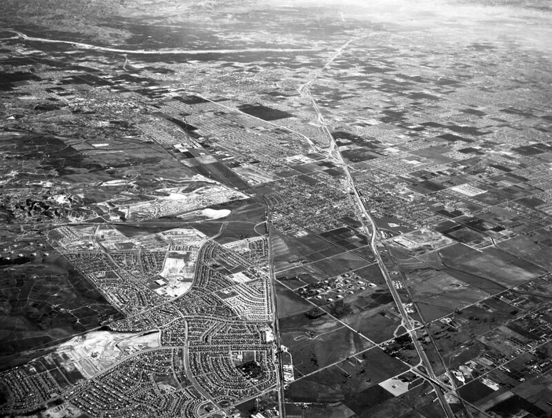
Aerial view of the Central Manufacturing District La Mirada area, located within the cities of Commerce, Bell, and Vernon view is looking southeast toward Buena Park and Anaheim. Alondra Boulevard is diagonally, bottom right corner to center left the Santa Ana (5) Freeway is diagonally, bottom right to upper middle Valley View Avenue is diagonally, bottom middle to lower right the Santa Fe Railroad runs up at middle and Beach Boulevard is horizontally at top. Photograph dated December 3, 1957.
Comentarios (2)

avatar

lillyly  27 de junio de 2019 a las 03:02

It doesn't ring a bell

avatar

alexanderich 24 de febrero de 2020 a las 15:56

Brilliant


Regístrate o loguéate para poder comentar y aportar tu granito de arena 

avatar

aubreyh 
715 fotos

125 West 54th Street, north side between 6th and 7th Avenues, showing the P.S. 6970, 72 and 74 Grove Street, south side, from West 4th Street (left) to Seventh Avenue South (right).Seventh Avenue South, west side, Bleecker to Grove Streets4th Street (right), and Washington Place (left), east from Grove StreetSeventh Ave., east side, north from West 47th to 51st Streets


Fotos cercanas

La Mirada, looking southeastLa Mirada, looking southeastWilshire Oil Corp., looking northeastGemco, looking northeastGemco, looking northeastMeyer RoadGemco, looking northGemco, looking northwestThe aerial lookLa Mirada, looking east

Foto publicada el
 11 de junio de 2019 a las 05:12


© Howard D. Kelly
Todos los derechos reservados

Imagen utilizada mediante las condiciones "Fair Use"


Old photos of Santa Fe Springs,Old photographs of Santa Fe Springs,Old images of Santa Fe Springs,Old snapshots of Santa Fe Springs,Old panoramic views of Santa Fe Springs,Old prints of Santa Fe Springs