Carson Flood Area

1956

Carson Flood Area

0 0 

United States United States > California > Los Angeles County > Carson
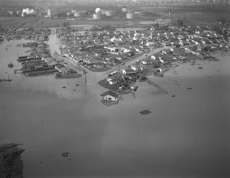
Aerial view of flood areas in Carson as a result of the January 26, 1956 storm view is the vicinity of Avalon Boulevard and 190th Street (near the present site of Cal State University, Dominguez Hills). A muddy lake of varying depths submerged a two-block-long stretch and many persons were forced from their homes as the floodwaters raged through certain parts of the city, making it impassable. Photograph dated January 28, 1956. The point was determined by historicaerials, but could not be found.
Comments (0)


Register or login to comment and contribute to the community 

avatar

matt_kj 
966 photos

New-York, Times Square by night, 1995-1996Park Avenue. Lever House, general view with reflections.Eldridge T. Gerry, 5th Ave. 61st St., N.Y.Harlem Meer, Central Park. View looking north toward West 110th Street and Lenox Avenue863 Park Avenue and 77th Street. Apartment House.


Nearby photos

Carson Flood AreaCarson Street Elementary SchoolCarson Street and Main Street, looking southwestCarson Street and Main Street, looking westCarson Street and Main Street, looking northwestCarson Street and Main street, looking northwestEast 218th Street and East 218th PlaceDolores Street, looking northwestCarson Street and Main Street, looking northwestEast 218th Place

Photo published on
 February 21, 2018 at 08:13 PM


© Howard D. Kelly
All rights reserved

Image used under "Fair Use" conditions


Old photos of Carson,Old photographs of Carson,Old images of Carson,Old snapshots of Carson,Old panoramic views of Carson,Old prints of Carson